Where the site is
On a plateau above the right bank of the Euphrates, with the river on one side, deep wadis on two more, and a single landward approach protected by a wall. It sat on the route between Syria and Mesopotamia and changed hands accordingly: Seleucid foundation, Parthian city, Roman frontier garrison.
- Ancient region
- The middle Euphrates
- Modern country
- Syria
- Position
- 34.747° N, 40.730° E — The Palmyrene Gate
- Given to three decimal places, about a hundred metres. It locates the named feature, not the extent of the site.
What survives
The circuit wall, the Palmyrene Gate, the grid of streets and the mudbrick houses, preserved partly because the defenders packed the buildings against the inner face of the wall with earth before the siege, burying and thereby saving the very buildings whose walls they were reinforcing.
Inside that fill were the two structures the site is known for: a synagogue whose walls carried a continuous programme of figural biblical painting, and a house converted into a church with a painted baptistery. Both were lifted and removed, the synagogue to Damascus and the church to Yale.
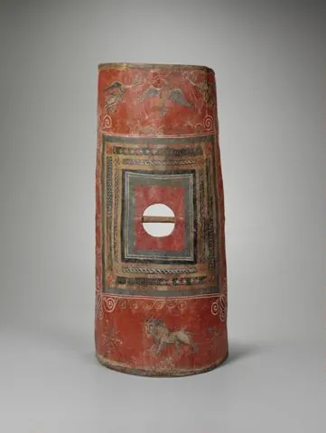
Also from the fill: the only substantially complete Roman body shield known, painted horse armour, weapons, and several hundred documents on parchment and papyrus in at least a dozen languages.
Occupation and chronology
Dates below are stored as signed years and rendered with the precision they actually carry. c. 300 BCE is approximate; c. 256 CE is approximate.
c. 300–113 BCE
Seleucid colony
A garrison colony on a grid plan, with a citadel above the river. The Greek name Europos and the Semitic Dura were both in use.
c. 113 BCE – 165 CE
Parthian city
Under Parthian control for nearly three centuries. This is when the mixed civic culture visible in the temples and the inscriptions takes shape.
165–256 CE
Roman garrison
Annexed under Lucius Verus and turned into a frontier base, with a military quarter walled off inside the town and a substantial documentary archive.
c. 253–256 CE
Siege and abandonment
A Sasanian siege, complete with assault ramp, mines and countermines. The town fell and was not reoccupied — the reason everything inside it survives.
History of excavation
Who recovered the evidence, when, and by what method. Where an excavation destroyed as much as it found, the entry says so.
- Evidence level: Documented
March 1920
British Indian Army troops digging trenches
Soldiers entrenching on the site cut into a painted wall. James Henry Breasted, then travelling in the region, was brought to see it within weeks and published the paintings, which is how the site entered scholarship.
- Evidence level: Documented
1922–1923
Franz Cumont for the French Academy of Inscriptions and Letters
The first excavation, which established the identity of the site and the presence of the temples.
- Evidence level: Documented
1928–1937
Yale University and the French Academy, directed by Michael Rostovtzeff
Ten seasons that uncovered most of the town. Clark Hopkins was field director when the synagogue was found in 1932. The division of finds sent a large part of the material to New Haven.
- Evidence level: Documented
1986–2011
The Franco-Syrian mission
Renewed work on the fortifications, the military quarter and the siege works, including the re-examination of the countermine that produced the interpretation below.
- Evidence level: Documented
2011–2014
Looting
Systematic illegal excavation during the Syrian conflict, documented from satellite imagery as many thousands of pits across the site. A large proportion of the unexcavated area has been destroyed as archaeology, and what came out of it has no provenance and cannot be used.
Principal structures
The evidence level answers how we know what a structure looked like, not whether it existed.
- Evidence level: Documented
rebuilt 244 CE
The synagogue
A house-form synagogue whose assembly room was painted floor to ceiling with narrative scenes from the Hebrew Bible — Moses, Ezekiel, Esther, the Temple. Its existence complicates any simple account of an ancient Jewish prohibition on figural art.
- Evidence level: Documented
converted c. 233–256 CE
The Christian house church
An ordinary courtyard house adapted for assembly, with one room fitted as a baptistery and painted with the earliest securely dated Christian figural scenes known.
- Evidence level: Documented
168 CE and later
The Mithraeum
A cult room with two carved reliefs of Mithras and painted zodiac figures, installed by Palmyrene archers serving in the Roman garrison.
- Evidence level: Documented
Seleucid, reinforced 250s CE
The Palmyrene Gate and the wall
The landward gate and the circuit, with the emergency earth rampart heaped against the inside during the final siege.
- Evidence level: Documented
c. 256 CE
The siege works
A Sasanian assault ramp against the wall, a mine driven beneath it, and a Roman countermine that met the attackers underground. One of the very few ancient sieges whose engineering can be walked over.
Finds and where they went
Almost nothing recovered from these sites is still on them. Where an object has a full provenance record on this platform, it is linked.
- Evidence level: Documented
The painted scutum
A curved Roman body shield of laminated wood and leather, painted with an eagle, lions and a ship. The only substantially complete example known, and the confirmation of a plywood construction described by Polybius and attested nowhere else in surviving material.
Yale University Art Gallery, New Haven, Connecticut · Full provenance record
- Evidence level: Documented
The synagogue paintings
The complete painted programme, lifted from the walls and reinstalled as a reconstructed room. Their condition and completeness are without parallel for any ancient religious interior.
National Museum of Damascus
- Evidence level: Documented
The Feriale Duranum
A parchment calendar of the religious festivals a Roman garrison unit was required to observe, listing imperial anniversaries and state cult. It is the single best document for the official religion of the Roman army.
- Evidence level: Documented
The documentary archive
Several hundred texts on parchment and papyrus — military rosters, duty rotas, loans, sales, marriage contracts, letters — in Greek, Latin, Aramaic, Palmyrene, Hebrew, Syriac, Parthian, Middle Persian and Safaitic. The linguistic range is the town's social history in one box.
Ancient testimony
No surviving ancient author describes the town in any detail. It appears in a handful of geographical notices and its fall is not narrated anywhere. Everything on this page comes from the excavation and from the documents found in it — which is unusual enough to be worth stating, because it means the site cannot be read through a text and has never been distorted by one.
How the site has been interpreted
Dura is the closest thing the Roman east has to Pompeii, and the mechanism is the same: an abrupt end with no reoccupation. What it preserves is different, though. Pompeii preserves a town's material life; Dura preserves a garrison's paperwork and a street of religious buildings belonging to communities that ordinarily leave nothing.
The synagogue and the church stood a few streets apart in a town that also had a Mithraeum, temples of Palmyrene and Mesopotamian gods, and a Roman military cult calendar. That is the strongest single piece of evidence for what religious life on the eastern frontier actually looked like in the third century, and it looks nothing like a sequence of exclusive traditions replacing one another.
The paintings also settled an argument by existing. Before 1932, the absence of figural art in ancient synagogues was widely explained as doctrinal. The Dura programme is elaborate, narrative, and was commissioned by the congregation whose donor inscriptions are on the walls.
The looting after 2011 is part of the site's record and belongs on the page. It removed context permanently from a large fraction of the unexcavated town, and it means that objects appearing on the market attributed to Dura cannot be treated as evidence about it.
Unresolved
Were the men in the countermine killed by gas?
Around twenty bodies were found in the Roman countermine, most of them Roman, in a confined space, with bitumen and sulphur crystals present. Simon James argued that the Sasanians deliberately generated toxic fumes to clear the tunnel — which would be the earliest documented use of a chemical weapon. Others hold that bitumen and sulphur were ordinary incendiary materials and that the fumes, however lethal, need not have been the intent. The bodies and the materials are documented; the intent is inference.
Why was the town not reoccupied?
The site sat on a good route and had water. Its abandonment after 256 has been explained by the collapse of the Roman frontier position, by depopulation from the siege, and by a shift of the frontier that made the position pointless. No single explanation is established, and the archaeology can only show that nobody came back.
How to read the evidence labels
- Evidence level: Documented
- Supported by a named primary text or by excavated material evidence.
- Evidence level: Probable
- Supported by strong inference that most specialists accept.
- Evidence level: Disputed
- Substantial specialist disagreement exists; competing readings are stated.
- Evidence level: Literary
- Belongs to poetic or mythological construction rather than to history.
- Evidence level: Mythological
- Belongs to shared religious or mythic tradition rather than to any single text.
- Evidence level: Unknown
- The available evidence is insufficient to decide.
These labels describe the status of the evidence, not our confidence in a conclusion. A claim marked Literary is not a claim we doubt; it is a claim about what kind of thing a poem is.